Tuesday, August 25, 2015

2015 Colorado Caching – Part 4

We had a relaxed rest day and went to a place called the Family Farm to eat and celebrate Kelly’s 40th birthday.  It was a fun and unique place complete with farm animals on premises.  We got to pet and feed the goats.  When we returned Kelly’s sister and mother were there with a birthday cake.

In late afternoon when I was inspecting my bike I noticed that my rear tire was quite worn.  I should have gotten a lot more miles out of it but I didn’t discover until I had returned home that it wasn’t the brand I thought I had on it (Continental ContiMotion) but instead a Shinko Advance.  By this time it was too late to get anything done in Denver.  The tire might have lasted the trip but I didn’t want to chance it and get caught in the middle of nowhere with a tire out.  I located a shop in Castle Rock south of Denver that we would be going through the next day that had a good tire at a reasonable price.

We got an early start the next morning trying to beat the Denver traffic because we had to get a cache in Denver County which is pretty much downtown.  The traffic wasn’t too bad, at least for Denver, and we found the cache without much trouble.  We wanted to be first in line at the bike shop so we didn’t take time to find any more caches in the county.

We found the shop a little after 8:00 and were first in line.  The service department didn’t open until 9:00 so we had a little wait.  We were another half hour actually getting in the shop after they opened and it was after 10:00 before we were back on the road.  Well, at least I would make the rest of the trip with peace of mind concerning the tire.

One of several desert caches 
After getting the new tire we set out east on Highway 86 toward Limon.  We were crossing counties we had done the previous year because we had to get to the far southeast part of the state for territory we hadn’t covered.  We stopped for an Elbert County cache before Limon just for a break and then shortly after turning south on Highway 71 at Limon we stopped for a Lincoln County cache and had a roadside lunch in the shade.

John W Rawlings Museum

As we proceeded down Hwy 71 we were soon in new counties the first of which was Crowley.  We got a couple roadside caches in that county before stopping in Rocky Ford to get one for Otero County.  At Rocky Ford we turned east on Highway 50 stopping in Las Animas bagging a cache at John W. Rawlings Heritage Center and Museum for Bent County. 


As the usual afternoon storm began, only this time accompanied by high wind and hail, we deviated from our planned route and headed straight into Lamar instead of making an out and back trip out to John Martin Reservoir and Kiowa County.  We stopped at the museum in Lamar and got a cache for Prowers County.  Then we found a nearby gas station with an overhang and took a break waiting out the storm at a table in the convenience store.


After the storm had abated we headed north on Highway to the little town of Eads.  I had chosen this little place to stay because of the reputation of a new motel there.  As improbable as it may seem, this little town of about 700 people had the grand Cobblestone Inn.  In talking to some locals later we found that some of the local farmers had all sold oil leases in one year and needed something to do with the money to avoid some taxes.  About 25 of them pooled their income and built this inn.  It wasn’t really a motel as it had no outside entrances but it was strictly first class.  They served the best breakfast there of anywhere we stayed as well.
Cobblestone Inn


Monday, August 24, 2015

DOGGIE TALES ON SMOKY DAYS


Over the weekend our valley filled with smoke from regional wildfires. Nevertheless, the dogs and I walked twice a day, and sometimes I carried the camera. The pictures here were taken Sunday, Aug. 23.

Mike left early Friday (Aug. 21) to attend the memorial service for his mother in Camden, Arkansas. He met sons Murray and Yancey at the Little Rock airport and they drove from there to Camden.

But – that isn’t my story. I stayed behind to take care of the dogs. And no one knows better than Bess and Nellie that I’m really not a dog disciplinarian. With a few whimpers, a push of the snout, or a soulful look, I can be had. We walked twice a day. We ate more than that. And I became adept at eating out of many dishes so that both dogs got a fair share of the lickings.

Walking the dogs has practically become a two-person event because Nellie lags behind while Bess is up ahead. It may surprise you to know that I am the fast walker and keep Bess in sight while Mike walks more slowly behind with Nellie. Especially on the return, Nellie slows way down, but we notice that if we put a leash on her, she steps right along.

Well, the other day as we were on the return side of our walk, Bess spied a jogger with dog up ahead and she was there! She took off running, and I whistled for her – an exercise in futility. After she and the stranger greeted, she continued running on down the road instead of coming back to me. Whistling was useless. As I continued at Nellie's moderate pace, I couldn’t imagine what was going through Bess’ dog mind to make her run like that, but then it occurred to me that we seldom blow the whistle during our walks. We whistle for her at the back door. I realized that the whistle drew a mind-picture of the house and that was likely where I would find her. Sure enough! When I got home, there she was. “Why did you want me to come here,” she seemed to ask. I commended her for coming home. I mean – what can you do?

That wasn’t as upsetting as what happened with Nellie. She and Bess went out Friday night after supper. Bess came back; Nellie didn’t. I assumed she would be right along and didn’t worry. Some minutes later, the phone rang. “Do you have a white shorthair,” the caller asked. “She’s in my back yard.” The man was really a neighbor located across the field from us, but in order to expedite matters, I drove there. As he escorted Nellie through the gate of his fenced yard, she took took off running across the street and into another back yard. From there she disappeared. I realized she was upset and just didn’t recognize me. I drove back home, got the leash, and headed out on foot. As luck would have it I found her half a block away and had no trouble getting her home. I should have kenneled her at that point, but I didn’t have the heart.

Then we had another adventure Sunday morning. As usual, Bess was a bit ahead while Nellie lagged behind. Lagging is one thing, but she wasn’t coming at all, so I turned back to “encourage” her. I saw her struggling somewhat in the middle of a weed patch, so I approached her to see what the trouble was. She was in a patch of puncture weeds. She would try to chew them out, but when she put her foot back down, she just picked up more. I had no choice but to pick her up and carry her out of that area. She hates to be carried, but it had to be done, and I was grateful I could do it. Once I cleared her feet of the puncture weeds, I discovered the soles of my shoes were just a solid mass of them.

Don’t you think I deserve a reward, though? I was thinking of adding Maryellen Larkin to my staff. KW


Sunday, August 23, 2015

2015 Colorado Caching – Part 3

The next morning we headed north on Highway 550 toward Montrose.  We stopped a short ways out of town in a little camping area where Yancey found one called “The Squirrel Stash”.  We didn’t stop again until we were east of Montrose on Highway 50.  When we turned east at Montrose the sun was right in my eyes and I had trouble reading my GPS.  Consequently, it took quite a while getting through town due to some missed turns.  We picked up some more along Highway 50. Along this stretch a dude tried to show me he could drive his Volvo better than I could ride my Triumph on the twisty hilly road.  After a little back and forth he relented.  I had gotten quite a ways in front of Yancey on this stretch so I stopped and waited at a roadside geocache.  It was shady and he zoomed right past me.  As soon as I got the cache I started after him but I knew I could never catch him.  After a short distance I got stopped at a road construction site.  I tried to call Yancey and as luck would have it he had stopped and climbed a hill to take some pictures just a little ways down the road so we quickly got back together.

Our planned route called for us turning south on Highway 149 west of Gunnison but due to fuel concerns we went on it to Gunnison to fuel up.  We then retraced back to 149.  Highway 149 was a very scenic route in high desert country with almost no traffic.  At South Fork we veered southwest on Highway 160.  We stopped a little ways past South Fork to pick up one in Rio Grande County.  I was relived because we were crossing the corner of Rio Grande County and I was concerned about being able to find one of only two I had lined up.  I believe it was just down the road that we stopped for a sardine lunch and the banks of the beautiful Rio Grande River.

Pagosa Springs
Working the combo
Teen Tribute
We continued south on 160 and went over Wolf Creek Pass and even stopped in downtown Pagosa Springs.  I got a kick out of that but Yancey had never heard of the C.J. McCall song “Wolf Creek Pass”.  What a city slicker!  We picked up an Archuleta County cache there at an Eagle Scout project in a park.  We left 160 for Highway 84 heading south to New Mexico.  It was beautiful country that Yancey particularly liked.  We just made a little loop in New Mexico and stopped for one cache called “All Aboard” on Highway 17 after we had turned back north.  It was a rather clever one that required you to figure out a combination on a lock to access the cache.  There was a little operating railroad there for tourists.
Railway in Chama, NM

We continued north back into Colorado and stopped at a 10,000 foot pass to get a cache that required a hike up the mountain side.  It was a beautiful view and I gave it a Favorite point.  Again it was late when we got in to Alamosa.  Every day we had been on the road in excess of 12 hours.  We stayed at another Super 8 in Alamosa and went to a Mexican restaurant recommended by the clerk at the motel.  It wasn’t up to Yancey’s standards (he’s a real Mexican food aficionado) but I thought it was good.  The only problem is that we got the buffet and as often happens in that situation I ate so much I was uncomfortable.

Saquache County is featured in Dayton Duncan’s book “Miles From Nowhere” that is about communities that are as isolated now as they were in frontier days.  Alamosa is just a few miles south of the Saquache-Alamosa county line.  I had located two caches about 35 miles north of Alamosa that I had hoped we could get with an up and back trip after we arrived at Alamosa.  However, it was just too late.  So we decided we would leave before breakfast the next morning, get the caches and come back for breakfast.  We were on the road before six heading across the sage brush and desert country.  The first cache was a micro sized one just off the highway.  Unfortunately we couldn’t find it.  I’m pretty sure it was gone.  Now I was really worried – just one more chance.  We continued north to the little community of Moffat and I was tremendously relieved when we found the cache at an old historic church there.  As planned, we zipped back down to the Super 8 for a nice breakfast.

Veterans' Memorial
After breakfast we headed east on Highway 160 toward Walsenburg.  We took a side trip on a very washboardy gravel road to get a “Veterans’ Memorial” cache for Costilla County.  Our first cache for Huerfano County was also down a gravel road but we elected to hike rather than ride this one.  The coordinates were off and we almost gave up before finally locating it.  We found one more for this county which was a kind of memorial for a teenager who had been killed.  At this spot we had an interaction with a state patrolwoman who pulled up on the shoulder apparently to meet another patrolman who showed up shortly.  Colorado must give their cops good training in PR because she was exceptionally cordial as was the patrolman we encountered on our trip the year before.


Before reaching Walsenburg we turned northwest on Highway 69 toward Silver Cliff.  This was hot desert country with little traffic.  At Silver Cliff we turned east on Highway 96 and attempted six caches between there and Florence finding only three.  Florence is where the Supermax Prison complex is and it is HUGE.  It’s where they house the baddest of the bad.  I had just read a Tom Clancy novel that told about the place.

We were now on the home stretch for this leg of our mission lacing only El Paso County as we headed toward Colorado Springs.  We managed two caches for that county – one at a lone grave on a steep hillside and the other at a pet cemetery.

Now the fun began.  We got on Interstate 25 and even Yancey said it was about the worst traffic he had ever seen.  It seemed to go for hours – speed up and then slam on the brakes and crawl for a while.  Finally as we got into Denver Yancey put us on some kind of expressway legal for motorcycles and we flew past those poor miserable souls on the regular Interstate.  It was good to get back to Thornton far a day’s rest.

Saturday, August 22, 2015

SMOKE

August 22, 2015 -- above Critchfield Road, Clarkston, WA


Wednesday, August 19, 2015

REGIONAL WILDFIRES


Smoke obliterates Lewiston Hill from view
[Over the past week, devastating wildfires have been fought in our region. Distant friends and family have sent inquiries as to the state of things here. Well, the Lewis-Clark Valley is not in the midst of fire but of smoke. The smoke is a constant reminder that citizens of neighboring communities are suffering this devastation. Up-to-date information can be sketchy; misinformation abounds. Local retailers, the Salvation Army, and others are assisting in efforts to gather emergency supplies for those without homes as well as firefighters.

Mike and I made a trip to the farm yesterday (Tuesday, August 18), traveling Hwy 12, Hwy 7 (Gilbert Grade to Nezperce), and Hwy 95. The fire is back and away from this route, but we saw plenty of smoke. They say this is the worst wildfire season in Idaho since 1926.

I’m reposting here Grandma Ina’s review of the Little Canyon Fire of 1934. In those days wildfires were fought by any able-bodied male, not trained firefighters. The new pictures were taken yesterday.]

LITTLE CANYON FIRE, 1934
The Dieterle place in Little Canyon
 The fire was pretty bad. The men fought it over two weeks, day and night, up and down the canyon. It destroyed a lot of pasture for the Dieterle boys and got Aunt Maud’s timber. It got the house, barn, 15 tons of hay, a lot of harness and farm machinery on the old John Shod farm about west across the canyon from us.


The fire spotted across the canyon onto the side of the bench on which stands “the old crag,” and was into our hay before we knew it. Shirley rushed out to get a view of it. I went to the telephone so as to send word to a threshing crew at the old Trutton farm. I tried to call Planks between times, but couldn’t raise them, so when Shirley came back I sent her over there for I was sure they were home, and sure enough they were and putting in hay. They just left the team standing and ran over. Well, in a very short time cars were arriving and men spilling out with sacks, buckets, shovels, etc. At least a dozen cars came and they fought it out of the gulch leading up behind June’s hen house and from Shockley’s and John Boehm’s. It might have got June’s buildings had it come up that gulch. 

They were on that job all Sunday night, Monday, and Monday night. I called for Earl at Dryden’s as soon as I could, and he made the grade in 15 minutes and drove right through to the syphon and went right on down to where the fire had started and fought it alone there for about an hour, then Jay Cordell and a few others thought they’d better go back down there instead of following the fire head, and he was mighty glad of help. 

Later that evening Henry Shockley came down, and he and Irl stayed down there all Sunday night. Earl came up and did chores Monday a.m. and took breakfast back to Henry. They dug a trench down the canyon side to the old road that day and back fired along it for there was danger of the fire crossing the canyon and coming down on our side and it would have just swept us clean if it had. 

Orofino barely visible from Gilbert Grade
You see, the grass is awful thick over west and this old fence row running through to the west from the “green grove” is a rod wide at least and a regular fire trap, so with a west wind I don’t think we could have saved the house after this grove got afire. 

The Saturday night before [this fire started] about 40 men went into the canyon and using Aunt Maud’s old road up the canyon as a break, they back fired to the creek to keep it from burning us out on this side, and then it spotted across and came up here after all. Henry and Earl stayed on the fire all day Monday. Shirley and Dad carried hot food and coffee to them as far as they could without going down the steepest part, over the bench. That night Earl came out again to milk and get more food while Henry pulled Mormon oats and made a bed for them, and they slept on the fire Monday night and put in most of Tuesday down there watching the back fire principally. Everything was so awful dry. 

. . . . It was surely an awful time, and the danger great. It went on way up the canyon and they had a terrible time with it up there and finally Lewis County sent a deputy sheriff with an experienced fire fighter to direct matters, and men rallied enough to put it out. The canyon doesn’t look so bad as you’d think for it burned in patches sort of.  . . . .  

We had a nice rain last Saturday night and it has cleared the atmosphere so that it is very beautiful now. Grain threshing is done long ago and bean threshing all done except a job or so.
Ina Dobson to her son Vance, 1934

Tuesday, August 18, 2015

2015 Colorado Caching – Part 2

Just a tin can?
I don't think so
Sunday morning Yancey and I set out on quest for the counties of the southwest quadrant of Colorado heading south on Highway 67.  Once we got out of the Denver traffic we had beautiful riding.  One of our first caches was a very interesting one in the community of Woodland.  What looked like just a rusted and flattened tin can actually had a pill bottle attached to its bottom fitted into a recess in the ground.  I doubt if I would have found this one but Yancey did.

Snair Cabin
Hartsel Days
At Woodland we turned west on Highway 24.  We stopped to get a cache at the “Snair Cabin” which was a cabin furnished just as it had been over 100 years ago when it was sturdily built and crafted by a wagon maker.  We stopped in Hartsel to get one at the old Hartsel school.  It just so happened that they were having Hartsel Days this weekend and things were really hopping.  We had to leave hurriedly to avoid being part of the parade which was about ready to start.  Just before reaching the town of Buena Vista we logged a cache called “John Denver’s Motorcycle”.  John’s motorcycle had been sold at auction but there was an interesting piece of machinery at the cache location.  We turned west on Highway 82 near Twin Lakes Reservoir and had lunch at a beautiful cache site called “Rushing Waters”.
NOT John Denver's motorcycle
Rushing Waters

We continued northwest picking up a cache or two before stopping in El Jebel to get one for Eagle County.  I had found a cache in this county long ago but it was before the date that the 64 County Challenge was posted so by its rules I had to get another one.  At Carbondale we turned south on Highway 133.  As it was getting late we didn’t stop again (except to put on rain gear) until Hotchkiss where we got our Delta County cache.  As it was now raining and we had our cache for Delta County we didn’t stop again until we reached our motel in Delta.  If you have proper gear riding in the rain isn’t too bad but stopping to get geocaches is.

It was raining in earnest when we reached the Rodeway Inn in Delta.  I had always thought that Rodeways were fairly high quality motels but this one was somewhat of a dump.  We did find a covered walkway at the end of the building to park our bikes out of the rain.  In view of the weather we had pizza delivered.  It was Philly Cheesecake and really good.  We had enough left over for our lunch the next day.

The rain quit during the night and it was dry in the morning as we headed northwest on Highway 50 toward Whitewater and Mesa County.  At Whitewater we turned south on Highway 141 all the way down to Dove Creek.  We saw some truly spectacular scenery on this road.  Much of it reminded us of our Utah trip a couple of years earlier.  We stopped for lunch at a cache called “Gyp Gap Rockshelter” that required a hike up a boulder strewn hill.  There was a small tree at the cache site that gave us shade for our lunch.  After we passed through Naturita and turned south toward Dove Creek we wisely returned to Naturita to gas up.  We were in desolate sparsely populated country.

We picked up several caches along this route and just past Lewis we turned east on Highway 184.  At Mancos Highway 184 merged into Highway 160 which took us southeast into Durango. 

Bolts gone
Bolts replaced
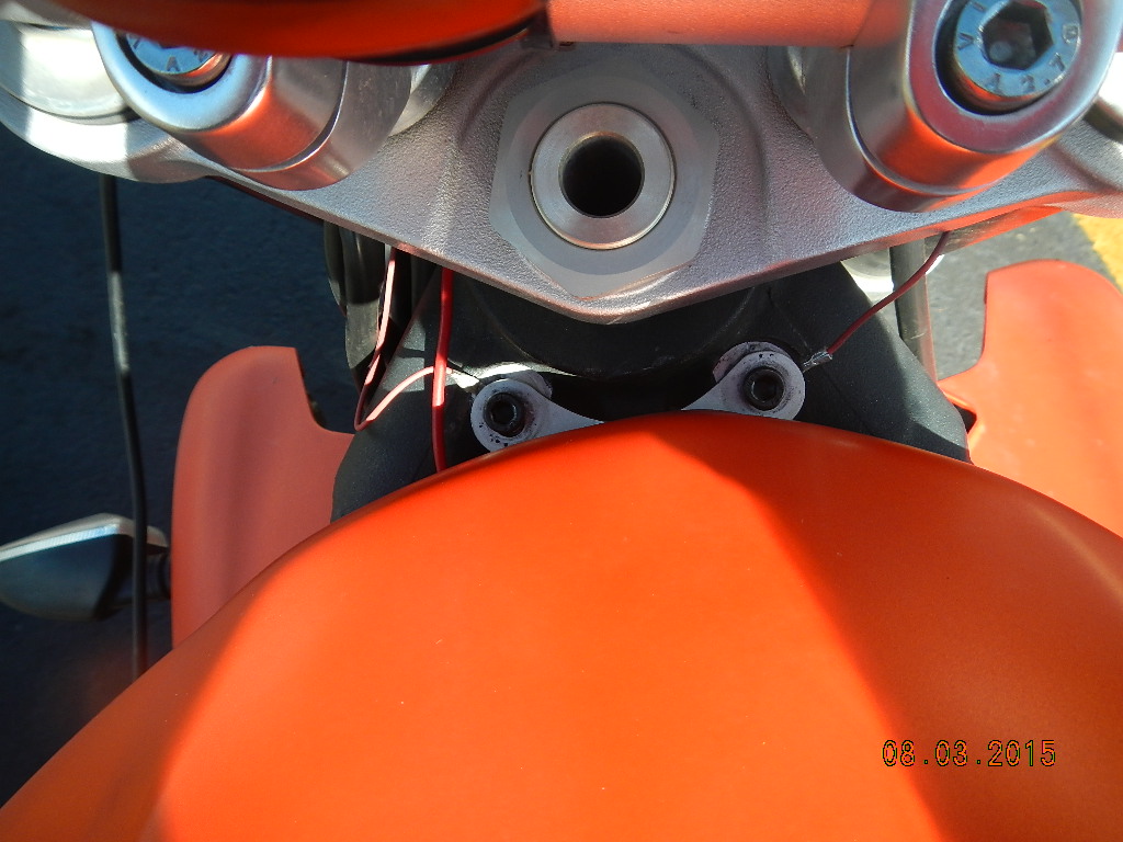
We stopped in Durango for gas and I always have to remove my tank bag in order to access my gas tank.  After doing so I noticed the two bolts that hold down the front of my gas tank were missing.  Before leaving home I had loosened those bolts in order to raise the tank just a bit to run my GPS cable under it.  Either I hadn’t tightened them back enough or more likely had forgotten altogether.  I inquired of a local and was told there was a hardware store just down the street.  I removed a bolt from one of my blinker lights that I thought was the same size as the ones I lost and took that into the hardware to find a match.  Luckily, in short order I found just what I needed and we were on our way.
Bear Creek Falls

As we headed north on Highway 550 out of Durango toward Silverton it began to rain.  We discovered this was pretty much an everyday afternoon occurrence.  Highway 550 between Durango and Ouray is called the million dollar highway.  It is a fantastic piece of highway and a local told is it was rated the 5th best motorcycling road in the US.  Unfortunately the rain ruined most of the uphill part for us.  However, it dried enough on the back side to allow some aggressive and fun riding.  On the way down we stopped at Bear Creek Falls which was absolutely spectacular.  We stopped at the bottom in Silverton to get a cache called “The Tree Farm”.  Incidentally, the big mine spill disaster occurred the day after we left Silverton.  We stayed at the Timber Ridge Lodge and were treated like royalty.  They gave us a thank you card, a small box of candy and called me a few days later to thank me for staying there.  That guy really knows his PR. 
Ouray


Ouray is very much a tourist town and reminded me a little of Red Lodge, Montana.  We hiked down town to a restaurant the lodge owner had recommended and had a very good meal.  It was dark by the time we got back to the lodge and we had no trouble sleeping that night.  Yancey even gave me a break on the snoring. [To be continued]  M/W